LAKE ERIE · LIVE CONDITIONS
Lake Erie Dashboard
Live buoy observations, wind and wave forecasts, shoreline cameras, marine alerts and seasonal lake information in one place.
CURRENT CONDITIONS
Lake Erie right now
Choose a reporting station to update the condition cards.
Wind
—
Waves
—
Water Temp
—
Air Temp
—
Find Conditions Near You
Enter a US ZIP code or Canadian postal code to find the closest active Lake Erie buoy or shoreline station.
Interactive Radar & Forecast Map
NOAA Buoy Data
Observations include NOAA/NDBC nearshore and offshore stations plus Canadian buoys carried by NDBC. Missing measurements are shown as unavailable, and stale stations are skipped.
| Station | Wind (kt) | Waves (ft) | Water Temp (°F) | Air Temp (°F) |
|---|
Sunrise • Sunset • Pressure
Daylight times based on Cleveland, OHLive Webcams Around Lake Erie
Eight useful shoreline and harbor views around the lake. We favor original camera operators and public agencies where possible; feeds open on the source site in a new tab.
Cleveland Lakefront Cam
EarthCam – live view of the Cleveland skyline and Lake Erie.
Detroit River Skyline Cam
SkylineWebcams – riverfront view with freighter and weather activity.
Perry’s Victory Observation Deck
National Park Service webcams from 317 feet above Lake Erie at Perry’s Victory & International Peace Memorial.
Lampe Marina / Erie, PA
Lake Erie marina, launch-ramp and harbor view provided through the Erie-Western Pennsylvania Port Authority partnership.
Port Dover Lake Erie Cam
Official Norfolk County marina webcams with Port Dover lighthouse, lake and waterfront views.
Marine Forecasts & Warnings
Use official marine forecasts and active warnings alongside buoy observations before heading onto Lake Erie.
NWS Nearshore Forecasts
Lake Erie nearshore zones from Maumee Bay through the New York shoreline, including current advisories and marine messages.
Open NWS nearshore forecasts →NWS Open Lake Forecast
Forecasts for Lake Erie waters beyond five nautical miles from shore, including synopsis, wind and wave guidance.
Open Lake Erie forecast →Canadian Marine Forecasts
Environment Canada forecasts, waves and warnings for the Canadian side of Lake Erie.
Open ECCC Lake Erie forecast →Beach & Marine Alerts
Data sources: NOAA NDBC, NWS (api.weather.gov).
ISLANDS · HARBORS · SHORELINE TOWNS
Around the Lake
A regional guide to fishing, boating, islands, beaches, wildlife and places to explore around Lake Erie.
Fishing & boating
Fishing reports, regulations, launches, marinas, ferries and harbor resources.
Islands & shoreline places
Put-in-Bay, Kelleys Island, Presque Isle, Port Dover and other lakefront communities.
Wildlife & seasonal Erie
Bird migration, parks, beaches, lighthouses, winter ice and year-round lake ideas.
Winter Mode: Ice Coverage & Safety
Lake Erie Surface Temp & Ice (NOAA GLERL)
Daily map from NOAA GLERL. Blues and grays show cold water / ice; warmer colors mean open water.
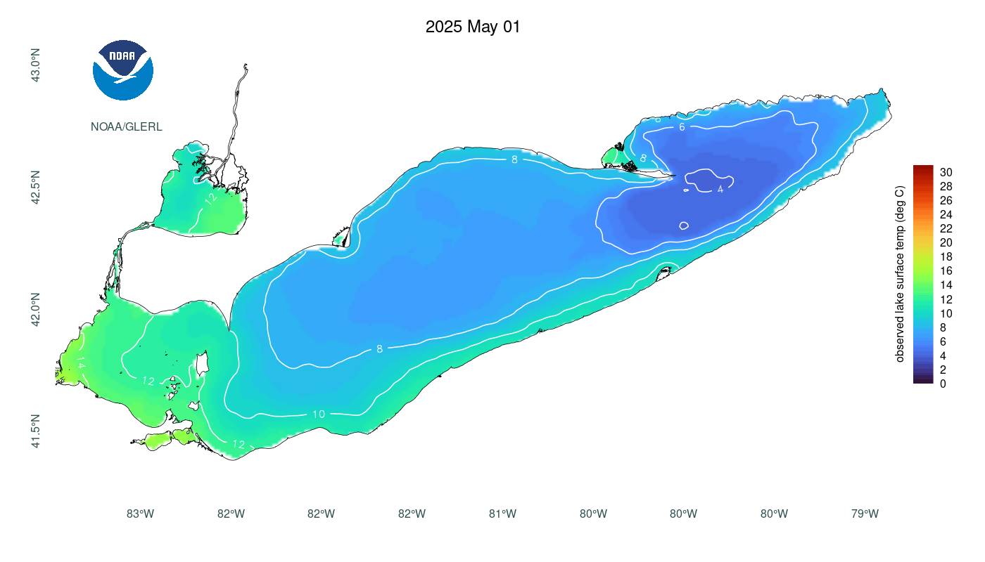
Updated daily via NOAA GLERL / CoastWatch.
Ice Safety Quick Notes
- 4″ of new, clear ice – minimum for travel on foot.
- 5″–7″ – typical guidance for snowmobiles & ATVs.
- Avoid inlets, outlets, harbors, pressure cracks & moving water.
- Remember: thickness can change fast on Lake Erie. No ice is 100% safe.
Check official conditions before heading out:
- NWS Great Lakes Ice Analysis →
- GLERL Lake Erie Ice Forecast (experimental) →
- Ohio DNR Ice Thickness Guidelines →
This dashboard is informational only. Always follow local advisories and on-site conditions.
Winter data: NOAA GLERL (GLSEA/GLCFS) & NWS Cleveland ice analysis; safety guidance adapted from Ohio DNR.